Colorado Springs Airport (COS)
Orientation and Maps
(Colorado Springs, Colorado (CO), USA)
The second-biggest city in the state of Colorado and located close to the world-famous Pikes Peak, Colorado Springs is especially appealing during the summer months. The city is also fairly busy outside of this peak season and many people head to Colorado Springs during the winter months, to enjoy the spectacular natural scenery around the red sandstone structures in the Garden of the Gods, which attract around two million visitors every year.
On the eastern side of the city and off the US-24 (East Fountain Boulevard), the Colorado Springs Municipal Airport (COS) is situated along Drennan Road and is a popular alternative to the more northern Denver International Airport (DEN). Buses around the area are run by TMN&O and link nearby Cheyenne, Pueblo and Wyoming, with the terminal being located on Weber Street. The Colorado Springs transportation center can be found on East Kiowa Street and features route maps for all of the bus lines, of which there are more than 30.
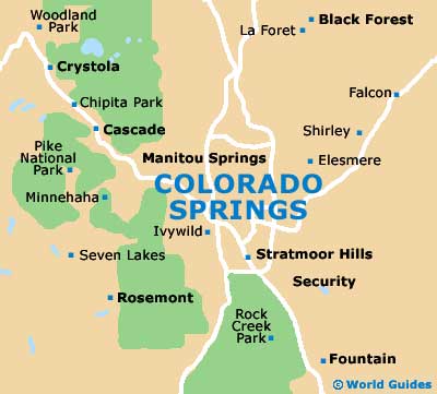
Colorado Springs Airport (COS) Maps: Important City Districts
The center of Colorado Springs is divided by the I-25 interstate, with the main Central Business District (CB) being located to the east and the Old Colorado City to the west, together with the small and appealing town of Manitou Springs.
City maps and pamphlets about the main tourist attractions are available at the Colorado Springs Visitors Center along South Cascade Avenue, and also at the office of the USFS Pikes Peak Ranger District on South Weber Street. Amongst the area's most popular attractions, the Pikes Peak Cog Railway dates back more than 100 years and offers spectacular views of the Colorado Springs area from the very top of Pikes Peak.
USA Map
Colorado State Map
Colorado Springs Map